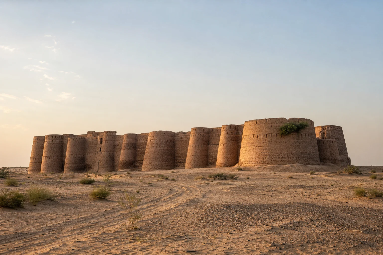
There are landscapes that ask to be read slowly. Cholistan is one of them. In this great southeastern reach of Punjab, known locally as Rohi, distance has its own measure: a line of dunes, a thorn tree, the dark shape of a camel herd, the faint glint of water held in a rain-fed reservoir. Then, with almost theatrical suddenness, Derawar Fort appears.
Its vast ochre walls rise above the sand in a square of baked earth and brick, punctuated by forty circular bastions. From a distance, the fort seems less placed in the desert than summoned from it—an enormous geometry against an uncluttered sky. But Derawar is not simply a spectacular ruin or a solitary emblem of royal ambition. It is part of a larger cultural landscape in which water determined power, travel and survival.
To understand the fort is to understand the apparent silence around it. Cholistan has never been an empty margin. It has been a lived landscape: a place of pastoral movement, seasonal judgement, trade routes, shrines, settlements and old river courses whose traces remain inscribed in the land.
A fortress on the edge of an old river world
Cholistan forms Pakistan’s western extension of the wider Thar desert. Archaeological work has linked its landscape to the former Hakra river system, whose dry course can still be recognised across parts of the desert. Long before Derawar’s imposing ramparts defined the horizon, settlements flourished along waterways that made cultivation and exchange possible. When the river system changed, the conditions of life changed with it.
The disappearance of a dependable river did not erase human presence. It altered it. Communities adapted to an arid world where rain, wells and stored water carried exceptional importance. Routes through the desert became matters of knowledge and necessity, connecting settlements across a region that was never as isolated as its modern image may suggest.
It was in this environment that a chain of forts developed across Cholistan. Derawar is the most visually commanding survivor, but it belongs to a wider network that includes strongholds such as Marotgarh, Islamgarh, Meergarh and others. Their forms vary, yet their purpose was closely connected: to oversee movement, offer security and exert influence over routes and water sources in a difficult terrain.
UNESCO’s tentative-list description of Derawar and the desert forts places particular emphasis on this relationship between fortification and water. A fort in Cholistan was not merely a military enclosure. It could be a landmark for travellers, a defended refuge, an administrative point and a strategic presence near vital supplies. In a desert, control of water is never only practical; it becomes a language of authority.
The many lives of Derawar
Derawar’s early history is not entirely settled in the historical record. It is widely associated with the Bhatti Rajputs and is traditionally attributed to Rai Jajja Bhatti in the early medieval period. The fortress visible today, however, bears the imprint of later rebuilding and expansion. Its history is best approached not as a single founding moment, but as a long sequence of occupation, contest and renewal.
In the eighteenth century, the fort became closely associated with the Abbasi rulers of Bahawalpur. Nawab Sadeq Muhammad Khan I took Derawar in 1733; after a period of loss, the Bahawalpur rulers regained it in 1804. It remained an important desert residence of the Nawabs well into the twentieth century. That prolonged association helped preserve Derawar when many other forts in Cholistan were abandoned, eroded or reduced to fragments.
This layered history can be felt in the fort’s scale. The enclosure is roughly square, with walls extending for about a kilometre and a half in total. Its forty bastions—ten along each side—do more than strengthen the perimeter. Their repeating curves create the fort’s unforgettable rhythm, while decorative brick patterns give an almost textile-like character to a structure built for defence.
The eye is drawn upward and outward: to parapets, bastions, shadowed openings and the changing colour of brick under a desert sun. Yet Derawar’s grandeur should not obscure its material vulnerability. Earthen and brick architecture can endure for centuries when cared for, but it is acutely exposed to rain, wind, salt, neglect and poorly considered intervention. The fort’s survival is a reminder that heritage is not preserved by admiration alone.
Beyond the walls: mosque, graves and the desert court
Near Derawar stands the Abbasi Mosque, a graceful nineteenth-century structure whose white domes and arches offer a striking contrast to the fort’s massive red-brown bulk. Its design is often noted for recalling Mughal-era forms, but its setting makes it unmistakably Cholistani: an elegant religious building poised in a severe, open landscape.
Nearby are the graves of members of the Bahawalpur ruling family. Together, the fort, mosque and cemetery create something more complex than a single monument. They form a desert ensemble in which defence, devotion, family memory and political history are gathered within sight of one another.
For visitors, this proximity can encourage a shallow reading: fort, mosque, tombs, photographs, departure. A more attentive encounter asks different questions. What did it mean to establish a courtly presence so far from a dense urban centre? How was food, water and labour organised? Who travelled through this landscape besides rulers and soldiers? What forms of local knowledge made life here possible before asphalt roads and motor vehicles altered the terms of distance?
Derawar does not answer every question directly. Its power lies partly in that restraint. Like many historic places, it carries absences as visibly as it carries walls.
The knowledge held by water
In Cholistan, water remains the key to reading the landscape. The desert’s rain-fed reservoirs, known as tobas, collect water in shallow depressions or prepared basins. Their condition has long shaped the seasonal movement of people and livestock. When rain is generous, grazing can revive and temporary settlements gather near water. When supplies diminish, families and herds may need to move towards other sources.
This is not a romantic tale of desert hardship. It is a sophisticated, demanding way of living with uncertainty. Pastoral and agro-pastoral communities have developed knowledge of grazing, animal care, rainfall, routes and water storage over generations. Camels, cattle, sheep and goats are not decorative elements in a desert scene; they are central to household economies and to the practical rhythms of mobility.
Seen in this context, Derawar’s location gains a fuller meaning. The fort stands within a terrain where the ability to find, protect and manage water shaped both daily life and long-distance travel. The desert’s apparent stillness is therefore deceptive. It records repeated movement: caravans seeking a stopping point, herders adjusting to weather, pilgrims on established routes, officials travelling between centres of authority, and families following the conditions that made another season possible.
From caravan horizon to cultural landscape
It is tempting to treat desert forts as isolated relics of a vanished age. Cholistan resists that simplification. The fort network points to a connected world extending beyond the dunes, while the older Hakra landscape suggests still deeper histories of settlement and exchange. Derawar belongs simultaneously to the history of Bahawalpur, the wider desert cultures of Punjab and Rajasthan, and the long human story of adapting to changing water systems.
That is why the fort matters beyond its silhouette. It challenges the assumption that Pakistan’s cultural life is concentrated only in its large cities, famous monuments or mountain valleys. Here, heritage is dispersed across open country. A crumbling wall, a dry riverbed, a toba, a herd moving between grazing grounds and a desert shrine can all be part of the same cultural map.
Derawar and the Desert Forts of Cholistan have been on Pakistan’s UNESCO Tentative List since 2016. Tentative-list status is not the same as World Heritage inscription, but it recognises the significance of the wider ensemble and its relationship between human settlement and an exacting environment. The designation also encourages a necessary shift in perspective: from seeing Derawar as one photogenic monument to seeing it as part of a fragile, inhabited landscape.
How to approach Derawar with care
A journey to Derawar should begin with humility. The desert can be intensely hot, remote and changeable, and conditions should be checked locally before setting out. Travellers should arrange reliable transport, carry sufficient water, respect access rules and avoid entering unstable or restricted portions of historic structures. A fort built of brick and earth is not strengthened by casual climbing.
Equally important is respect for the people whose lives continue around the site. Ask before photographing individuals, homes, animals or religious spaces. Dress and behave with consideration, avoid leaving waste in the desert, and remember that a landscape may be both a destination for outsiders and a working environment for local families.
The finest response to Derawar is not to conquer it with a checklist. It is to pause. Watch how the bastions darken toward evening. Notice the scale of the sky, the sparse vegetation, the tracks that disappear into sand. Think of the fort not as a lonely object, but as a surviving witness to a desert civilisation of water, movement and endurance.
In Cholistan, silence is not an absence of story. It is the space in which stories travel far.